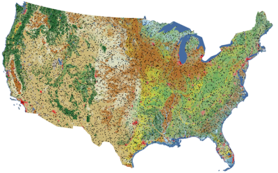
Time-Series Data
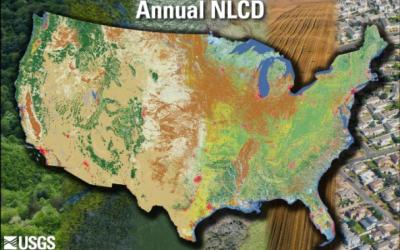
Rangeland managers need information on the current vegetation condition and how the landscape has changed through time. To address this need, scientists from the USGS and Bureau of Land Management (BLM) developed the Rangeland Condition Monitoring Assessment and Projection (RCMAP) project. U.S. rangelands are classified as fractional (0-100%) cover of ten ground cover components (annual herbaceous, bare ground, herbaceous, litter, non-sagebrush shrub, perennial herbaceous, sagebrush, shrub, tree, and shrub height). Maps are produced using Landsat imagery for each year in a time-series stretching from 1985-2024. This long-term perspective is key to understanding vegetation response to drought, invasive species, land management decisions, and disturbance. RCMAP time-series data enable retrospective analysis of vegetation condition, impacts of weather variation and longer-term climatic change, and understanding of vegetation treatment and altered management practice effectiveness. RCMAP also produces a series of Trends analysis which depict the net changes in cover over the time-series in addition to highlighting significant change events (break points).
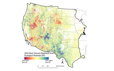
Ecological Potential
In addition to time-series products RCMAP produces Ecological Potential and Future Projections. Ecological Potential fractional cover products represent the potential cover given the most productive, least disturbed, portion of the 1985-2024 Landsat archive. Models used to predict Ecological Potential cover were trained on ecologically intact sites where annual herbaceous cover is low, no known disturbance or land treatment has occurred over the study period, and bare ground cover is relatively lower than expectations. Ecological Potential data can serve as a baseline for comparison of current rangeland vegetation conditions and trends. Contemporary component cover in 2024 was compared to Ecological Potential cover to generate departure maps. Additionally, we converted Ecological Potential and actual cover maps for 1985 and 2024 into vegetation states. These general vegetation states (native sagebrush steppe, annual grasslands, etc.) highlight locations where vegetation communities have already changed or are vulnerable to future change.
Future Projections
RCMAP future projections include three time periods (2020s, 2050s, and 2080s) and two climate scenarios (Representative Concentration Pathways [RCP] 4.5 and 8.5). Future predictions are based on neural network models trained on annual weather conditions and component cover in the historical period (1985-2023) and applied to future climate data. Component projections are designed to be used individually or combined to support a broad variety of applications. Data are packaged by time-period and climate scenarios (six). Additionally, for comparison to reference conditions, a scenario based on 1991-2020 climate normal is available.
For more information see: https://www.usgs.gov/centers/eros/science/rangeland-condition-monitoring-assessment-and-projection-rcmap
For additional information on RCMAP product accuracy variation by ecoregion, cover value, and spatial scale, see here