The Annual National Land Cover Database (NLCD) impervious surface product provides the fractional or percent surface area of a 30-meter map pixel that is covered with processed materials or structures (pavement, concrete, rooftops, and other constructed materials) that generate surface runoff. The majority of these materials are impervious to water, but many features that are not impervious like lawns and channelized ditches also contribute to surface runoff and water impairment.
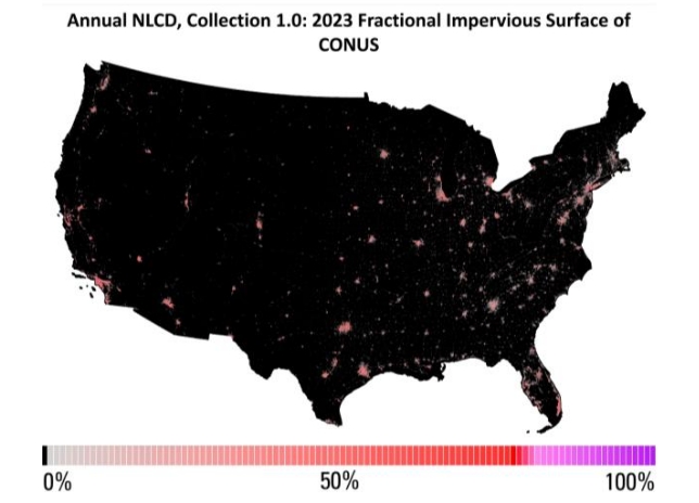
The amount of impervious surface is generally less than suggested by the footprint of developed land cover because these classes often include permeable but developed vegetation, such as lawn grasses, that may be the majority surface cover. The impervious surface product provides a value for every land cover pixel mapped as developed and determines which intensity category the pixel will be placed into based on thresholds described in the primary land cover class legend in the Science Product User Guide. The value ranges from 0-100% area.
Data Access
Information about data access is available on the USGS Annual NLCD Data Access page.
Documents
Additional information on Annual NLCD and Annual NLCD science products can be found in the Science User Product Guide.
Annual NLCD Citation Information
Annual NLCD has no restrictions on the use of science products. Annual NLCD does ask that if you use the data as part of a publication or presentation that use the following citation below; however, it is not a requirement to use the data.
U.S. Geological Survey (USGS), 2024, Annual NLCD Collection 1 Science Products: U.S. Geological Survey data release, https://doi.org/10.5066/P94UXNTS