The Annual National Land Cover Database (NLCD) Impervious Descriptor product provides a map of road networks within impervious areas and distinguishes roads from other built surface classes.
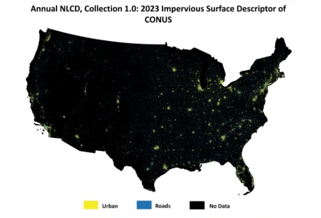
Caption: The Annual NLCD impervious descriptor product generates a raster layer that differentiates between urban and road surfaces.
The Impervious Descriptor product provides additional categorical information for urban and rural areas. The Impervious Descriptor product classifies impervious areas of the NLCD Land Cover product into road and urban (i.e., other built surfaces) classes. Unlike versions of NLCD prior to the Annual NLCD Collection 1 edition, this is not a reporting layer for urban source information but is the direct result of a supervised classification algorithm.
Annual NLCD Impervious Descriptor Legend
| Class\ Value | Classification Description |
| 0 | No Data |
| 1 | Roads |
| 2 | Urban |
Data Access
Information about data access is available on the USGS Annual NLCD Data Access page.
Documents
Additional information on Annual NLCD and Annual NLCD science products can be found in the Science User Product Guide.
Annual NLCD Citation Information
Annual NLCD has no restrictions on the use of science products. Annual NLCD does ask that if you use the data as part of a publication or presentation that use the following citation below; however, it is not a requirement to use the data.
U.S. Geological Survey (USGS), 2024, Annual NLCD Collection 1 Science Products: U.S. Geological Survey data release, https://doi.org/10.5066/P94UXNTS